τοπία που έχουν υποβληθεί από χρήστες
Έχουμε τοπία για τις επτά ηπείρους (στο μοντέλο για τις επτά ηπείρους) - για όλες, συμπεριλαμβανομένου και της Ανταρκτικής!
τοπία:
διαπλανητικό
| Screenshot not available |
Apollo 11 landing site |
0.9+ |
| Mathew Myrup |
N/A |
English |
| This landscape is made using NASA photographs taken by Buzz Aldrin. Look down and you can see Buzz's footprints :) |
| Screenshot not available |
Apollo 17 landing site |
0.9+ |
| Mathew Myrup |
N/A |
English |
| This landscape is made using NASA photographs taken by Gene Cernan. |
| Screenshot not available |
International Space Station |
0.9+ |
| Makc |
GPL |
English |
| Landscape made using some screen shots and data from the wonderful Celestia. Set the projection mode to stereographic, zoom out to a wide field of view and point down towards the ground to get the nice rounded "planet" effect. |
 |
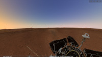
Husband Hill, Mars |
0.9+ |
| Johan |
Public Domain |
English |
| Johan transformed this Mars image from NASA into a spherical panorama that can be used with Stellarium. Mars rover Spirit made this image during August 24 to 27, 2005. Image credit: NASA/JPL-Caltech/Cornell. Read more on this webpage. |
 |
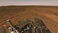
Mars Opportunity Rover |
0.9+ |
| Mike |
Public Domain |
English |
| Mike sent posted this landscape in the forums. Another nice Mars rover landscape. |
 |
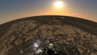
Mars (Utopia Planitia) |
0.9+ |
| Ray |
CC BY-SA 4.0 |
English |
| The panoramic view of the landing site (Utopia Planitia of Mars) is a 360 degrees ring shot taken by the navigation terrain camera on the mast of Zhurong, the Chinese Mars rover of Tianwen-1, after correction and mosaic stitching. The image shows that the terrain near the landing site is flat, the Martian horizon can be seen in the distance, and the abundance and size of the rocks are consistent with expectations, indicating that the autonomous selection of the landing site and the implementation of hovering obstacle avoidance are effective. The Mars topography map is the first topography and geomorphology image map taken by the navigation terrain camera after the rover reaches the surface of Mars.
Image credit: China National Space Administration. |
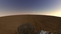 |
Mars Panorama of Phoenix Landing Site |
0.9+ |
| Alexander Wolf |
Public Domain |
English |
| This view combines hundreds of images taken during the first several weeks after NASA's Phoenix Mars Lander arrived on an arctic plain at 68.22 degrees north latitude, 234.25 degrees east longitude on Mars. The landing was on May 25, 2008. Image credit: NASA/JPL-Caltech/University of Arizona/Texas A&M University. Read more on this webpage. |